Historical Sites on ADV Bikes: Sunnyside

Keith Dishong • December 20, 2025

Tired of riding the same routes each month? Get out and explore Arizona's rich history with our series of Historical Sites for ADV Bikes! 

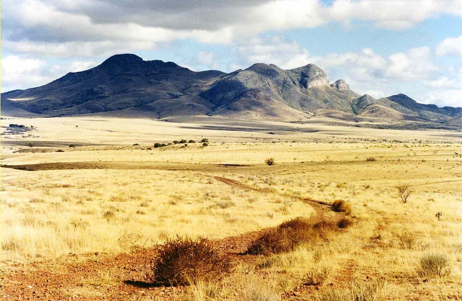
Getting to Sunnyside we'd rate at a 2 out of 5 difficulty rating. It's a great offroad section that easy enough for beginners with one mild technical dry creek crossing. The road is big bike friendly. If you continue past Sunnyside, you'll run into slightly more technical terrain, but again, nothing we'd consider difficult, even on the largest ADV bikes. Enjoy the history:


In the rugged, pine-scented folds of the Huachuca Mountains in Cochise County, Arizona, lies a history that reads more like a screenplay than a municipal record. Long before the suburbs of Tucson adopted the name "Sunnyside," a different community by that name thrived in a remote canyon, born from the spiritual fervor of a reformed sailor and sustained by the "common purse" of a communal mining experiment.

The story of Sunnyside, Cochise County, is a tale of religious zeal, copper dreams, and a specific brand of frontier socialism that existed nowhere else in the Wild West.

The Founding: Samuel Donnelly’s Revelation

​The origin of Sunnyside is inseparable from its founder, Samuel Donnelly. Born in Scotland in 1852, Donnelly was a man of extremes. He spent his youth as a merchant seaman, allegedly living a life of "worldly" vices before a transformative experience at a Salvation Army meeting in San Francisco. Donnelly became a "two-fisted preacher," a charismatic figure who believed that the corruptions of the city were the greatest threat to a Christian life. In the mid-1880s, looking for a place to establish a utopian community, Donnelly turned his eyes toward the newly opened territories of Arizona. He wasn't just looking for a pulpit; he was looking for a livelihood. Donnelly acquired an interest in a mining claim on the western slopes of the Huachuca Mountains. By 1888, he had led a small band of followers—later dubbed the "Donnellites" by outsiders—into Sunnyside Canyon to build a town where work was worship and wealth was shared.

Operation: The Donnellites and the Communal Mine

​Unlike the lawless mining camps of nearby Tombstone or Bisbee, Sunnyside was a model of sobriety and order. The town’s operation was built on three core pillars: mining, communalism, and strict moral discipline.

  1. ​The Copper Glance Mine: The economic heart of Sunnyside was the Copper Glance Mine. While many residents also worked at the nearby Lone Star Mine, the Copper Glance was the community’s project. Every man in the camp worked the mines or the sawmill. There were no private accounts. The profits from the ore were placed into a "common purse" used to provide for everyone’s needs, regardless of their specific job or status.
  2. Social Life in the Canyon: At its peak, Sunnyside housed between 80 and 100 residents. Life was simple but surprisingly rich in culture.Most meals were eaten together in a large tent or timber-framed dining hall. This fostered a sense of kinship that was rare in the highly individualistic West. Donnelly forbade saloons, gambling halls, and "camp followers" (prostitutes). To those living in the violent shadow of the O.K. Corral era, Sunnyside was a peaceful anomaly. Despite the remote location, the community valued refinement. Families owned instruments—including at least one rosewood piano hauled up the mountain—and children attended a one-room schoolhouse that doubled as a chapel.
  3. Religious Structure: The Donnellites practiced a form of "Primitive Christianity." There was no formal church building; instead, the canyon itself was the sanctuary. Donnelly preached daily, emphasizing that the physical labor of clearing rock and timber was a spiritual duty.

The Collapse: Floods and Failing Health

​The fragility of a utopian community often lies in its dependence on a single leader or a single resource. Sunnyside had both vulnerabilities.

​In 1898, a catastrophe struck the Copper Glance. Miners accidentally breached an underground aquifer, causing a massive influx of water that flooded the shafts. In an era before high-powered electric pumps, the mine became a watery tomb for the community's primary source of income. Without the "common purse" to sustain them, the Donnellites began to drift away. The final blow came in April 1901, when Samuel Donnelly died of Bright’s disease. Without his charismatic leadership to hold the commune together, the religious experiment effectively ended. By 1903, the town was nearly a ghost town.

The Second Life: Ranching and the CCC

​Sunnyside didn't disappear immediately. In the 1910s and 20s, the area saw a small revival as a ranching community. A post office was established in 1914 and operated until 1934, serving the rugged homesteaders of the San Rafael Valley. During the Great Depression, the area's operation shifted again. The Civilian Conservation Corps (CCC) established a camp nearby in 1933. These young men built the roads and fire lookouts that still exist in the Huachucas today, living in the same canyon where the Donnellites had once sung hymns.

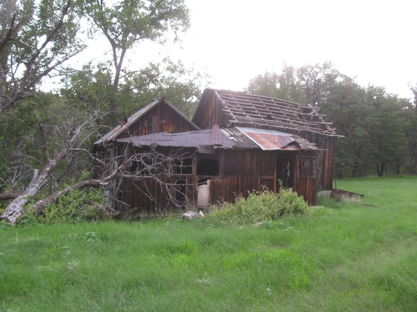
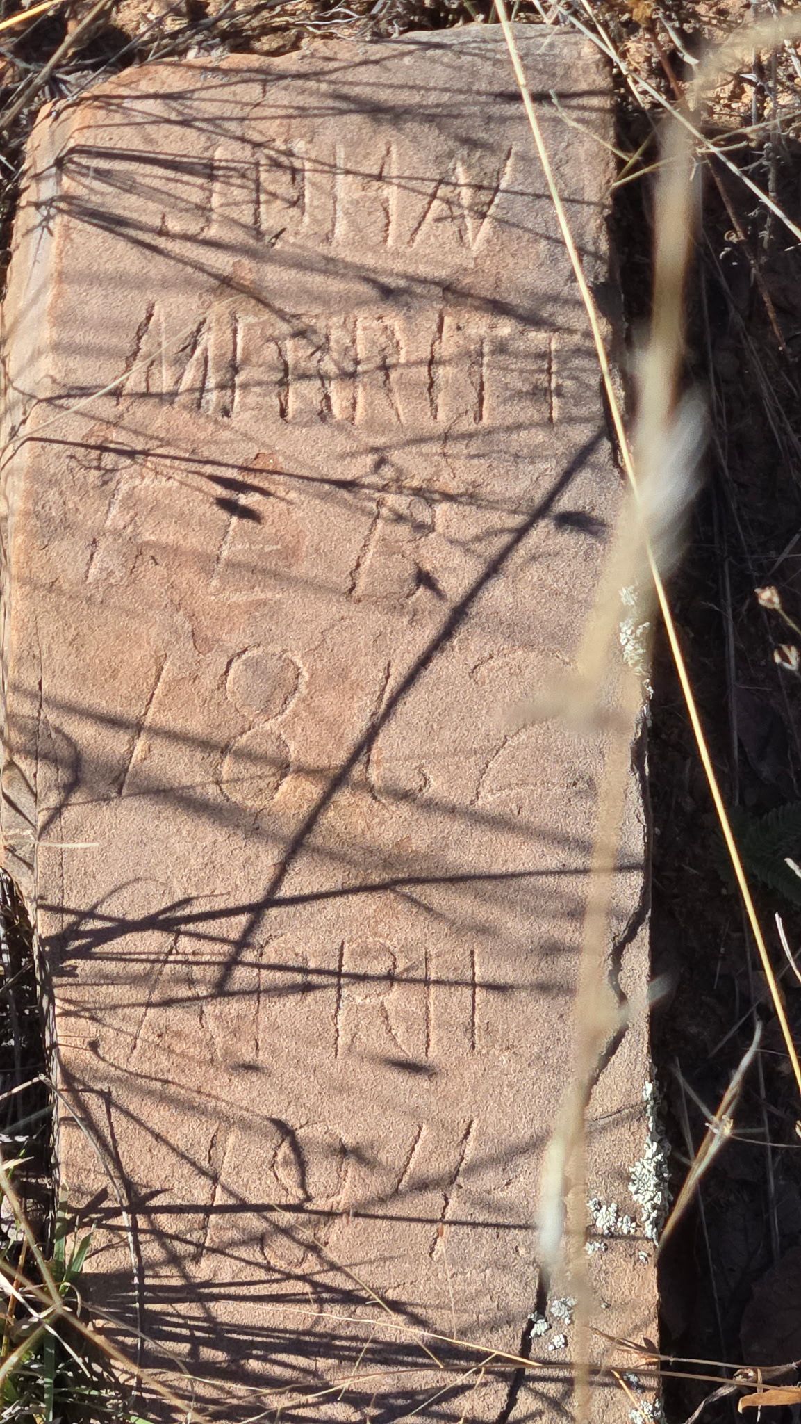
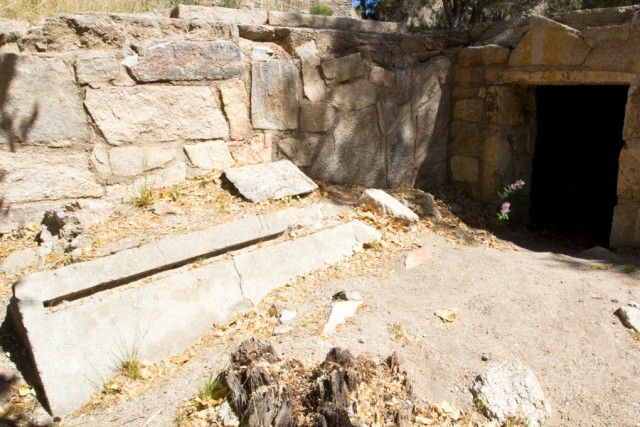
Sunnyside Today: A Modern Ghost Town

​Today, Sunnyside is located within the Coronado National Forest. While most of the timber structures have rotted away, the stone foundations and the ruins of the "Hot House" remain as silent witnesses to Donnelly’s dream.The town remains a destination for hikers and history buffs, particularly those trekking the Arizona Trail, which passes near the site. It stands as a reminder that the history of Cochise County is more than just gunfights and outlaws—it was also a laboratory for those trying to build a better world in the middle of the desert.

By Keith Dishong & Scott Arkon January 10, 2026
a self assessment chart for adv rider to better determine their skills in relationship to ADV trails. Beginner, intermediate and advanced riders can distinguish.
By Keith Dishong December 26, 2025
In the heart of the Superior Arizona, landscape, two geological giants stand as silent sentinels of the past: Picketpost Mountain and Apache Leap. If you’ve ever driven US-60 between Phoenix and Globe, you’ve seen them - one a solitary, flat-topped butte that looks like a fortress, the other a massive, jagged escarpment that glows deep crimson at sunset. These are not just beautiful formations for hikers to conquer; they are sites steeped in a complex, tragic history where Native American endurance, military strategy, and mining booms collided. The Sentinel: Picketpost Mountain Picketpost Mountain is an unmistakable landmark. Rising 4,375 feet above the desert floor, it looks like a natural castle guarding the town of Superior. Long before it was Picketpost, Spanish and Mexican explorers called it Tordillo (Grey Spotted) Mountain. Its current name was born from the Apache Wars of the 1870s. General George Stoneman, a prominent military figure (and later the Governor of California), established an infantry camp at the mountain’s base in 1870. The mountain served as a "picket post" - a military term for a sentinel or lookout position. Soldiers were stationed on the broad, flat summit to signal movements across the desert below. Because of its height, it later became a vital link in the heliograph network, a communication system that used mirrors to flash Morse code across Arizona’s mountain peaks. A Volcanic Giant Geologically, Picketpost is the remnant of a massive volcanic vent. Over millions of years, the surrounding softer rock eroded away, leaving behind the hardened "latite" lava that forms the mountain's formidable cliffs. This geological "hard-headedness" is what gives Picketpost its iconic, impregnable look. The Legend: Apache Leap - The Leap of Honor Directly to the east of Superior lies Apache Leap, a stunning vertical cliff that forms the edge of the Galiuro and Superstition transition. Its beauty, however, is inseparable from a haunting oral tradition. According to the legend, in the early 1870s, a group of Pinal Apache warriors were surprised by U.S. Cavalry troops in a pre-dawn raid. Outnumbered and backed toward the edge of the sheer 1,000-foot precipice, the warriors faced a grim choice: surrender and face life in captivity, or die on their own terms. The legend says that nearly 75 warriors chose to leap to their deaths from the summit. It is a story of profound sacrifice and refusal to yield. The Apache Tears Local lore links this tragedy to a unique geological feature of the area: Apache Tears. These are small, translucent pebbles of black obsidian found in the perlite deposits at the base of the mountain. The story goes that the wives and families of the fallen warriors gathered at the base of the cliff to mourn. Their grief was so great that the Great Father embedded their tears into the earth as black stones. When held up to the light, these "tears" are clear, representing the sorrow and the spirit of those lost. Superior: The Town Caught in the Middle The presence of Picketpost and Apache Leap defined the fate of the town of Superior. In 1875, silver was discovered at the foot of Picketpost Mountain, leading to the creation of the Silver King Mine - the richest silver strike in Arizona history. The boom town of Pinal City sprang up at the mountain's base, housing figures like Wyatt Earp and Doc Holliday. When the silver eventually ran out, the focus shifted to the copper veins beneath Apache Leap, giving rise to the Magma Mine and the modern-day town of Superior. Today, these landmarks are at a crossroads. The proposed Resolution Copper mine project aims to tap into a massive copper deposit nearly 7,000 feet beneath the Apache Leap area. This has sparked a deep conflict between the economic potential of the mine and the cultural sanctity of a site that many Apache tribes consider sacred ground. Whether you see these mountains as sources of mineral wealth, military history, or spiritual significance, there is no denying their power. Standing in the shadow of Picketpost as the sun sets behind Apache Leap, you can almost hear the echoes of the "picket" guards and the mournful winds of the legends that define this rugged corner of Arizona.
Prison camp image on mt lemmon
By Keith Dishong December 1, 2025
Tired of riding the same routes each month? Get out and explore Arizona's rich history with our series of Historical Sites for ADV Bikes! Getting to Mount Lemmon Prison Camp we'd rate at a 1 out of 5 difficulty rating if you only take the highway up and down. With 26 miles of curves each way; it's the perfect summer ride in Southern Arizona because of the massive drop in temperature towards the top. The prison camp is at mile marker 7 as you ascend the highway and is a great place to camp if your planning an overnighter. Weekends get busy on the mountain, as you might expect, and slower moving traffic doesn't seem to recognize what the multiple pull-outs along the highway were designed for most of the time. For maximum enjoyment, we recommend riding Mt Lemmon on weekdays. To make this ride dirty, ride the offroad section on the backside of Mt Lemmon from Oracle! Maps call it the Arizona National Scenic Trail. Difficulty peaks at a 3.5 out of 5 and we recommend you be an intermediate rider or better if you're attempting it on a big ADV bike. Most of the way up the mountain it's an easy, well groomed, road but as you start climbing in elevation the road turns rocky and loose in sections. Riding this road up or down the mountain is spectacular but this road does close for the winter months so check with locals for when the gates open/close. May to October it's usually open. Enjoy the history:
lochiel arizona golden field
By Keith Dishong November 15, 2025
Tired of riding the same routes each month? Get out and explore Arizona's rich history with our series of Historical Sites for ADV Bikes! Reaching Lochiel ranks a 1 out of 5 difficulty rating unless it's rained and made a mess of the road... then it becomes a 2; still beginner friendly just be vigilant. After leaving Patagonia, pavement fades fast, replaced by wide dirt roads, washboard, loose rock, and the occasional sandy section; making it ideal for riders who like their scenery remote. The route flows through open ranch land and high-desert grasslands with long sightlines, minimal traffic, and plenty of free-range cattle that couldn’t care less about your travel plans. It’s not a technical beatdown, but it’s remote, quiet, and unforgiving if you’re unprepared, ending at the eerie border ghost town of Lochiel where history, isolation, and a strong “don’t break down here” energy collide. Enjoy the history: